
The number one question I get when people are visiting New York is, “how do I get around?” If you’ve ever been lost in a city, it can be intimidating!
Thankfully, New York had over 22 million visitors and they do everything they can to make it easy on you! The more preparation you do, though, the better your trip will be!
First things first, you need to familiarize yourself with the districts in NYC. One lady on a bus asked us which stop to get off at. When I asked her where she was trying to go she said, “Manhattan.” Manhattan is huge and getting lost is a real possibility!
Walking through the city
The city of New York is mapped out like a grid. Here’s a guide that will help people think you’re a local!
Streets – Any numbered road that’s labeled “street” goes east to west. Ex. 24th St, 48th St, etc. The grid goes from 1st street all the way up into the upper 100’s. You likely won’t go north of Central Park, which is 110th street. South of 14th street, not every street follows the same grid-like pattern. Once you get further south, you’re likely in SOHO and headed towards Downtown, which does not follow the grid method. The blocks that go between Streets will take you 1-2 minutes to walk per block.
Avenues – Avenues numerically range from 1st Ave. to 11th Ave. and they run North and South. The higher up in number you go, the further west you are (or near Jersey). For example, 11th Ave. is closest to the views of Jersey. The lower down in number you go, the further east you are (or near Queens/Rossevelt Island/Brooklyn). There are some tricky additional avenues and sometimes they have multiple names. For example, 4th Ave is also Park Avenue and there are a few extra avenues on the east side of Manhattan like Madison Ave, Lexington Ave, and York Ave. Those are in between your standard 3rd Ave, 4th Ave, and 5th Ave. For the most part, Avenues take 3-5 minutes to walk between.
For example, walking from 5th Ave to 6th ave along 48th St. will take you longer than walking from 48th street to 49th street along 5th Ave. Confused? Here’s a map!

Then, there’s this cool little twist in the city and knowing this will make the walking experience a lot more fun!
Introducing….BROADWAY!!
I know what you’re thinking and, no, I’m not referring to the Broadway musicals you can see in New York! Broadway is also a street that runs diagonally through the city! But here’s what’s cool: everytime Broadway intersects with an Avenue, there’s a city park, square, or circle.
Think: Columbus Circle, Times Square, Madison Square, Herald Square, Union Square…you get it. Madison Square is also home to the famous Flatiron Building, which is why it’s iconic triangular shape was actually just created out of necessity to accomodate Broadway!

Whenever I lived in NYC (for a short period of time for week) and everytime I visit, my favorite part is always just walking through the city. You can see a lot of different districts and note how they change in a few blocks! I’ve also stumbled upon some really awesome food finds and stores when I simply walk the city! Broadway is a great street to just walk on because you can see several squares and famous parks.
Here are some good reference points:
Central Park: 59th St – 110th St., 5th Avenue – 8th Avenue/Central Park West
Midtown: Generally speaking it’s 40th St-59th St from 5th Ave – 8th Ave (or the 20 blocks south of Central Park)
SOHO/Chinatown/Little Italy/Downtown: outside of the “grid” streets
Here is a great map of the different districts in New York City. I also found this site, which has a lot of great resources for getting around in NYC too!

Navigating the Subway
The subway payment system is run by OMNY now, which means that you can tap your phone (Apple Pay) or your credit card if you have the tap feature instead of buying a Metrocard! Starting Monday of each week, you pay for your first 12 rides ($3/ride) and the rest of the week is free!
There are 6 different lines that run through NYC and it’s boroughs and there are different buses within those six lines. Here’s a map:
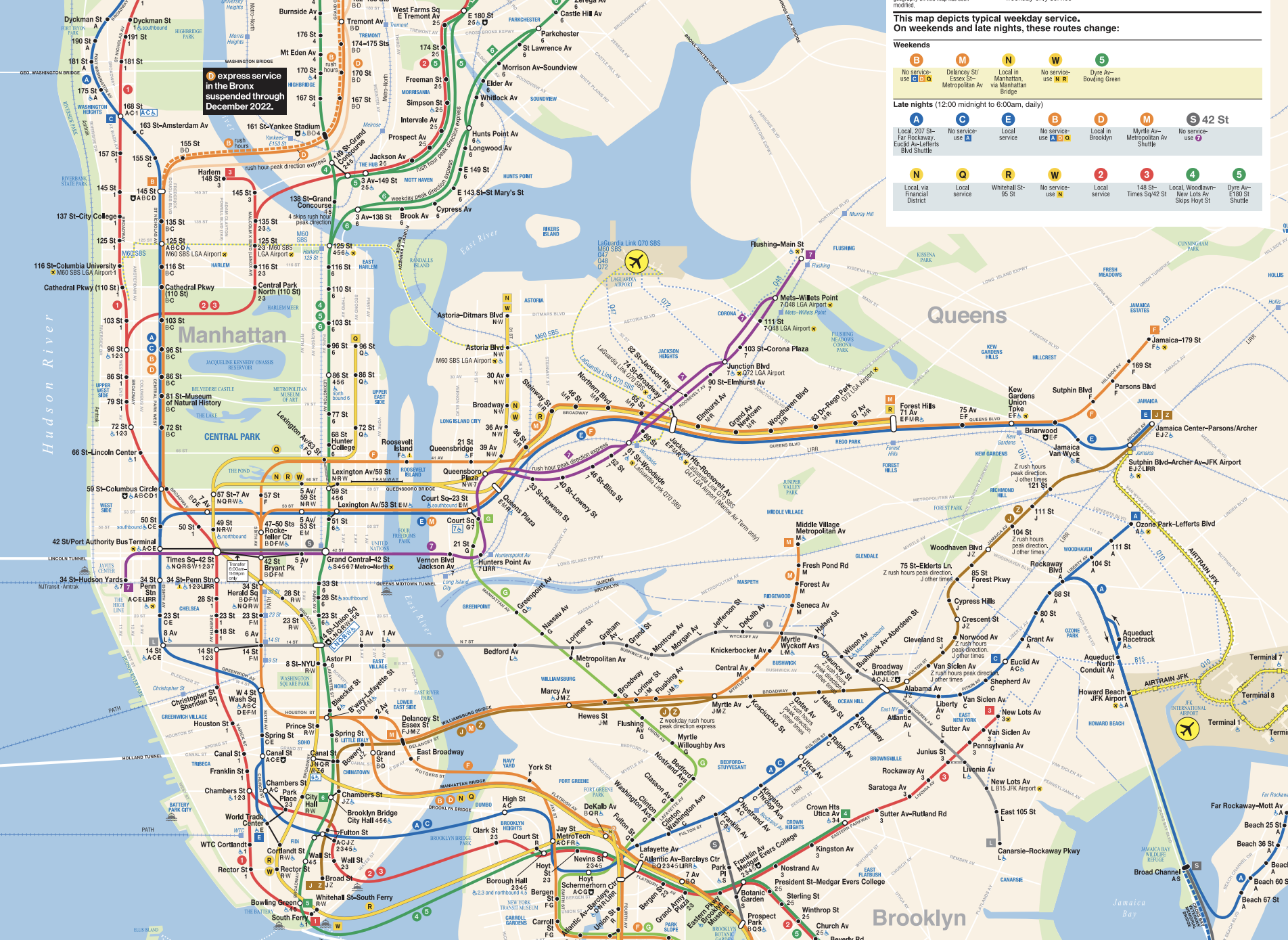
Knowing which subway to take when can be tricky without Google of Apple Maps. But, as you can see, most subways will stop at the same places as other subways that can get you where you need to be. Just use your Maps app ahead of time to plan!
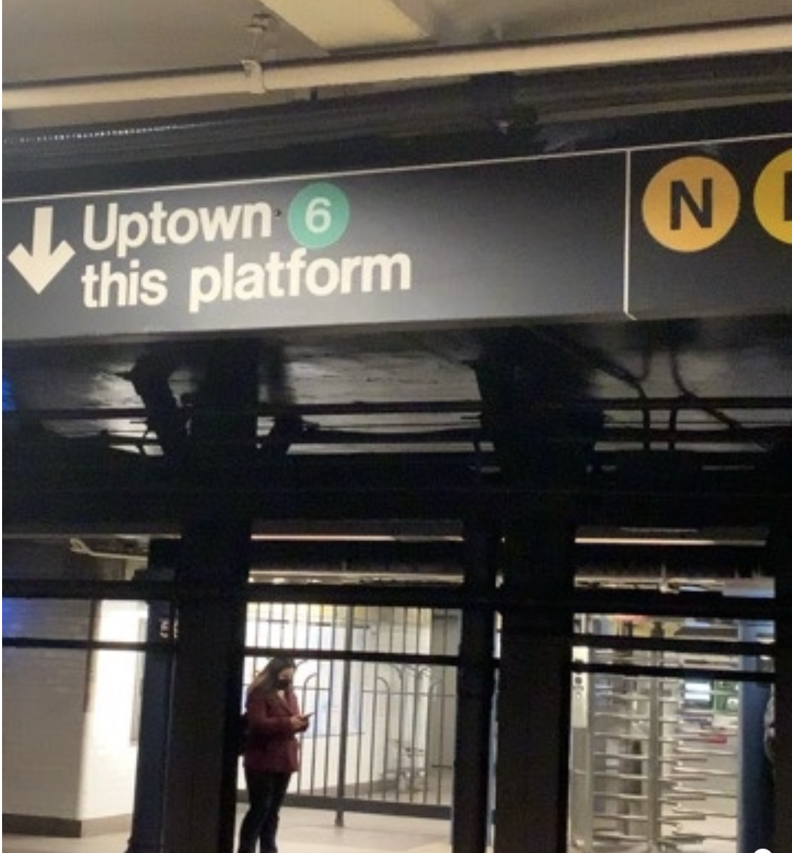
When you get on the subway, make sure you know if you’re going north or south. North will be labeled “Uptown” or “Uptown & Brooklyn” and south will be labeled “Downtown” or “Downtown & Brooklyn.” You don’t want to waste time getting on a South-bound train when you are trying to go North. Pay attention to the way the subway platforms are labeled! It’s clear, you just have to pay attention to it.
It’s good to have a basic understanding of North & South in New York City. For reference, Brooklyn is south and Queens is East like towards La Guardia Airport. This is especially helpful when getting off the subway. Each set of stairs or Exit sign should say the streets you’ll come out at and sometimes even the directional corner (Ex. SW Corner of 48th St & 6th Avenue). This is helpful because you can orient yourself when you come up from the subway station.
Let’s play this out…
You pull up at 48th St. & 6th Ave. You see signs saying “SE corner of 48th St.” If you’re trying to go to Bryant Park Winter Village, you want to go to 42nd St. and 6th Ave. You walk up the stairs to be at the SE corner. That puts you here:

You know that you need to walk South in order to get to 42nd St. or, Bryant Park Winter Village. You know you’re at the South East corner so you’re safe to walk along 6th Avenue, since those run north and south. When you see the next block says 47th St, you’ll feel like you’ve hacked the system and you’ll officially feel confident getting around in NYC!
Happy touring!!

One thought on “Navigating New York City”